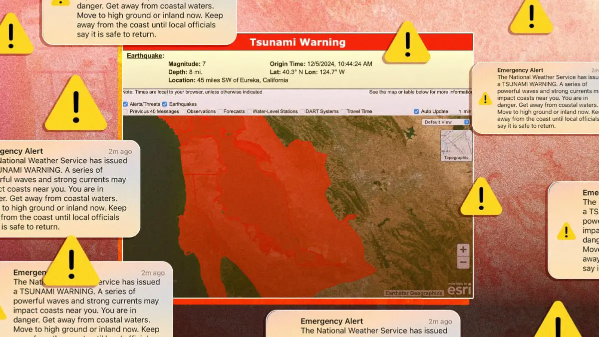
The tsunami warning that came screaming through my cell phone at 10:51 a.m. was blunt: “You are in danger.”
The warning applied to 5.3 million people in California, according to the Associated Press, although not all received it — and many who did were shocked into disbelief.
A tsunami here? Impossible, I thought, at first. I live east of San Francisco, more than a mile inland from the Bay shoreline, about two hundred feet above sea level.
Then I thought: I need to get to my kids.
How to connect your iPhone to a satellite to send messages
I wasn’t sure how a 7.0 magnitude earthquake hundreds of miles north of me could prompt a warning like the one I received from the National Weather Service.
But I also know enough about earthquake science and the west coast’s seismic, volcanic “ring of fire,” to understand that my state exists on the precipice of tectonic plates, both underground and deep in the sea. And that the tension in those plates can translate to unimaginable power.
One day, those underwater plates may cause a catastrophic rupture, one that leads to a deadly tsunami. Was this the day?
I needed to get more information about our risk, but doing so proved more difficult and confusing than I expected. I ultimately encountered an alarming map that indicated my family was indeed in a warning zone, but I had no guidance about what to do as a result.
Why so many people got the tsunami warning
I didn’t know it at the time, but that warning map was not quite correct for my location and “not the best warning decision tool,” according to David Snider, the tsunami warning coordinator for the National Oceanic & Atmospheric Administration.
In an interview, Snider also explained that the federal agency’s tools for alerting the public to a tsunami are more imprecise than we might expect, thanks to the way that geographical boundaries are drawn.
If I’d been enjoying a day on the coast, I would’ve been grateful for the potentially lifesaving text message. But based on my location at the time, I probably shouldn’t have gotten the blaring alert. Snider said this message is sent automatically via the Wireless Emergency Alert System following a tsunami warning.
Meanwhile, some people in the Bay Area didn’t get that alert on their phones, but received news via text from their counties that it had been canceled. Others received nothing at all.
A “critical need in our next level of service is communicating to folks in exactly the right areas,” Snider said, “and helping people know who don’t need to move, that they don’t need to move.”
The map that nearly made me panic.
Credit: U.S. Tsunami Warning Center
Snider added that the tsunami warning center website is undergoing major upgrades to improve the way that warning maps are visualized, which should clarify risk levels in the future.
But he also noted that those boundaries reflect the NWS’ weather forecasting and alert zones, among other factors. Here’s what that can mean: people who live near the shoreline or coastal waterways may be lumped into the same geographical area of people not far from the ocean but closer to elevated terrain, such as the Oakland and Berkeley Hills.
The result: a terrifying warning map where the entire San Francisco Bay Area is blanketed in red.
A crisis in believability
As a journalist with science reporting experience, I have a high tolerance for nuance and caution in moments of crisis. I understand that warnings are necessary to prevent death and disaster, even if the worst possible outcome never transpires.
But to be caught in limbo, with a serious warning and not much else, is to feel a unique kind of terror. It’s the kind of fear, multiplied by thousands of individuals, that can generate widespread distrust of government experts and authorities. Over time, that mistrust can curdle into resentment.
Mashable Light Speed
For example, look at the replies to the National Weather Service’s announcement on X that the tsunami warning had been canceled. One user accused the federal agency of lying to protect their “fat salaries / pensions / benefits.” Another paged DOGE, the X account for Elon Musk’s new government-slashing initiative otherwise known as the Department of Government Efficiency.
Tsunami warnings are rare, compared to other natural disasters like hurricanes and wildfires. And as Snider pointed out, people in immediate potential danger on the coast appeared to have heeded the alarm, followed directions, and started evacuating. In that sense, the system worked.
But if there were ever a time for disaster and emergency authorities to be highly communicative with the public, this moment was it.
Was I at risk?
Personally, I couldn’t wait to confirm whether or not I was truly in danger. My family’s emergency bag, which I’d needed to be ready if the tsunami waves arrived at San Francisco by 12:10 p.m., as they’d been forecast, was incomplete.
It was during that frantic hour of packing the emergency bag, while searching for information, that I came across the NWS’ tsunami warning system map.
The San Francisco Bay Area was covered in ominous red, indicating that everything in its domain — including my own home and my children’s school — was subject to the warning.
This was hard to square with the phone alert I received, which said I needed to move to high ground, or inland, immediately. But what if I was already there and still under threat?
Plus, here’s where a little knowledge might be a dangerous thing. I’d seen a different government map of the local tsunami risk, made several years ago. That map identified coastal waterways as the only danger areas.
So which map was right?

The emergency alert received by the author.
Credit: Rebecca Ruiz / Mashable
Later, Snider told me that the tsunami warning system map didn’t show precise tsunami hazards at the community level, so it’s not “the complete story which helps all end users have a total answer in that moment.”
But at the time, my mind scrambled for answers.
I imagined that a major tsunami-level surge in the Bay, which covers 1,600 square miles, could send water and debris rushing inland. The 2004 Indian Ocean tsunami, which killed 230,000 people, led to flooding three miles inland in some places. Images from that tragedy are still seared into my memory.
Still, I couldn’t find any trustworthy explanations for why this warning covered so much of the Bay Area, or what I should do next.
Should I simply drive east, away from the Bay and ocean? That would take me through the Berkeley and Oakland hills, very high ground, the kind you’d assume was safe — but the hills were also technically covered by the warning. The text alert didn’t point recipients to a website or resource for real-time updates or instructions.
I heard from no government official after the warning was issued. Looking at California Gov. Gavin Newsom’s X account later, I discovered that he didn’t post about the tsunami warning until it was canceled.
My children’s school district sent a message out nearly an hour after the initial warning. “We are being advised to keep everyone in place,” it said.
Though the National Weather Service is my go-to source during natural- and weather-related events and disasters, the agency’s tsunami alerts account on X had posted only the warning.
The NWS Bay Area X account posted a single update between when the warning was issued and when it was cancelled. “We are still waiting for magnitudes of water rise,” it read. “We will update you as we learn more”.
Friends reported trying to find the same information I had, but said that reliable websites timed out on them. Then, just before noon, the warning was canceled.
“Based on all available data… the tsunami threat from this earthquake has now passed,” said the statement. It took about 15 minutes for county officials to text and email me that news.
What happens next time?
I don’t know the most effective way to warn millions of people about a possible tsunami. The most important thing is that the people living on the coast got the alert as quickly as possible. But I do worry that what happened could undermine trust in the warning system.
Snider said that future updates to Tsunami.gov could better reflect tsunami hazard areas, which are already well known and are currently available in map form at the state and local level.
He understands that the public wants and needs information specific to their location that’s streamlined and easy to access. Snider indicated that some of this work was already underway, in addition to upgrades to the tsunami warning system website.
The response to the earthquake and potential tsunami will be evaluated, Snider promised, with a focus on how information reached the public.
The forecasting and warning services that the National Oceanic & Atmospheric Administration provides are vital, but some members of the public may just assume the worst about what happened. Maybe they’ll think the government sometimes tries to scare us for its own nefarious reasons. Perhaps they’ll think the hard-working scientists behind the models that warn of potential disaster don’t know what they’re doing, and they’ll turn to cranks or grifters making false pronouncements for clicks on social media instead.
Neither of these outcomes is good for the eroding state of trust in officials. Nor is the possibility that people will wave off future tsunami warnings if they felt like this one was unnecessary. Just because the threat of a tsunami was over just as quickly as it began doesn’t mean people won’t remember how they were warned — for all the wrong reasons.

